Volcán Barú is the highest point in Panama. It rises to about 3,500 meters. On a clear day, from its summit, one can see both sides of the isthmus of Central America: the Atlantic Ocean on one side and the Pacific on the other. It last erupted 500 years ago. It was a sudden explosion that reshaped the summit and left the volcano lower than it once was. According to a report by the US Geological Survey:
Given this history, Volcán Barú likely will erupt again in the near or distant future, following some premonitory period of seismic activity and subtle ground deformation that may last for days or months. Future eruptions will likely be similar to past eruptions—explosive and dangerous to those living on the volcano’s flanks. Outlying towns and cities could endure several years of disruption in the wake of renewed volcanic activity.
There are two routes to the top. One begins in Boquete. It follows a wide dirt road that is about 12 km long, often traveled by 4×4 vehicles. It is steep and long but technically straightforward. Many people ride up at sunrise or sunset to admire the views. The drive takes about two hours. On foot, the same ascent can take six hours or more. We chose the other route that ascends from the town of Volcán. We had no desire to share the trail with vehicles. As this route is steeper, narrower, and more technical, it promised more solitude. Our plan was to hike from the Volcán side up to Barú, camp overnight at the top to see the sunset and the sunrise, and then come down on the Boquete side the next day.
Regulations require hiring a guide for hiking the Volcán side of Barú. Which we did. We contacted Cesar who owns the Wonderlust Store in Boquete and David. He arranged everything for us: transportation from Volcán to the trailhead in Paso Ancho; luggage transportation from Volcán to Boquete (we had some extra luggage we did not need to bring all the way to the top and down again); rental equipment such as a tent, sleeping bags, and hiking poles; dinner and breakfast at the top. Everything went smoothly. Our guide, Edgar, took excellent care of us!
For our stay in Volcán and Boquete, before and after hiking Volcán Barú, see our other dedicated post.
Hiking up Volcán Barú
We left the town of Volcán at 6 am and reached the trailhead at Paso Ancho by 7 am, just as the day was waking up. The trail passes through strikingly different ecosystems. It begins gently and winds through dense forest, mostly flat or with little elevation. The trail then rears up into a steep section known as “the 45,” named for its near forty-five-degree incline. This part was humbling and relentless.
We stoped halfway through to watch several resplendent quetzals. They were singing and going after one another. Many females and one male. Our guide counted at least ten. It was rare to see so many together, he said. We stood there, looking up, letting the show of the forest unfold.
At the top of the 45 section of the trail, we reached a spacious wooden platform overlooking the valley and the town of Paso Ancho below. Just before the platform, a short uphill scramble offered an extra challenge, though there was also an easier bypass if we wanted an easier approach.


Beyond this point, vegetation thins out a bit and the trail becomes more exposed. The trail dips briefly, then climbs again over sand and scree. Since foot traction can be tricky, there are metal cables that run alongside the trail to help with balance. They are not necessary, but we often took advantage of them. This section was demanding, but also exhilarating and adrenaline-inducing at times.


By late morning, fog began to rise from the valley below, and we climbed enveloped in mist. The cold air bit at our hands, but the steepness of the ascent kept us warm. The cables continued for more than an hour, after which the trail turned toward the main crater. The terrain remained rugged, but wooden steps and railings appeared. The trail was very well maintained. We climbed through a narrow valley and finally reached the crater floor, where hikers can camp overnight.


There was still some elevation to gain before the summit. We reached the junction where the Volcán trail meets the trail from Boquete. Unfortunately, the weather had closed in. It was windy, foggy, and visibility was low. We decided to head down to our campsite at Los Fogones, about 3,300 meters. There are sturdy wooden platforms there where we could set up our tents. We rested for a bit, and then made one last push back to the summit for sunset. The fog remained stubborn, but the forecast promised clearing skies. So we chose to have hope the fog would indeed clear up for sunset.
Back to the top, a handful of people had arrived by 4×4 vehicles. We felt an irrational resentment. They hadn’t earned this place, we thought. The fog showed no mercy. The sun flickered faintly through the clouds, at times revealing sections of the blue sky. The clouds quickly closed up again. One by one, everyone else gave up and left. Soon it was just the two of us, our guide, and an engineer working on the antennas.
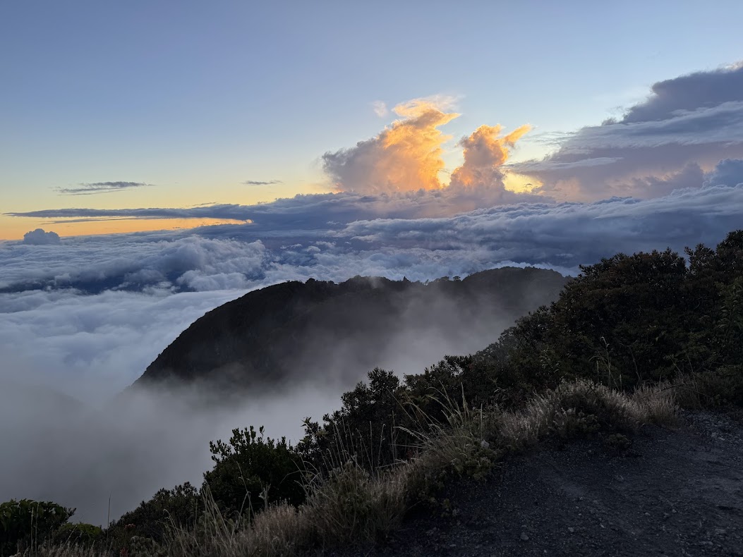
Then, suddenly, the fog went away. The clouds receded beneath us. The sky ignited in reds and golds. The Pacific Ocean appeared, unmistakable and vast. The world opened all at once, as if nature had been waiting for silence before revealing itself. It was breathtaking, almost unreal. Sometimes, all that is required is patience. We took pictures—many of them—but none could capture what we experienced. It was so unexpected. Magical. An awesome gift of sublime beauty from nature.


We walked back down to our tents, cooked a warm soup with our guide, and went to bed. The alarm was set early: 5:30 am. Sunrise would come around 6:20 am.
The next morning, we heard engines as early as 5 am, the growl of vehicles climbing toward the summit. We hiked back up in time for sunrise. This time it was crowded. Nearly everyone had arrived by 4×4. The summit was filled with people waiting for sunrise. The sky was clear, and both oceans were visible, stretching out on either side. Still, the moment lacked the surprise of the day before. Beautiful, but no longer intimate.
We returned to camp, had a hearty breakfast, and began the long descent to Boquete along the dirt road, now shared with the 4×4 vehicles. The walk down was uneventful, monotonous, exhausting. It seemed it would never end. We reached town around 1 pm.
We did it!


Trail Description
We provide below a more detailed description of the trail, also visible on AllTrails.
Starting point: Town of Volcán/Paso Ancho (trailhead about 1,950 m)
Summit elevation: ~3,474 m (11,398 ft)
Total elevation gain: ~1,550 m
One-way distance: ~8 km
Typical ascent time: 5–7 hours
Difficulty: Strenous with class 2 and class 3 scrambles
Required guide: Yes for the Volcán route
Section 1: Forest Approach
Distance: ~2 km
Elevation gain: ~150–200 m
Time: ~45–60 minutes
Terrain: Dirt, roots
Condition: Relatively flat
The trail begins gently, winding through dense forest with good canopy cover. Footing is stable and navigation straightforward. This section serves as a warm-up and is deceptively easy compared to what follows.
Section 2 : “The 45” (Steep Forest Climb)
Distance: ~1.5 km
Elevation gain: ~600–700 m
Time: ~2–3 hours
Terrain: Dirt, roots, rock steps
Condition: Narrow, sustained incline
This is the crux of the lower mountain. The trail steepens. It is often described as a near 45-degree incline. It is relentlessly uphill. Trekking poles are useful here. Near the top of this section is a small viewpoint platform overlooking Cerro Punta and the surrounding valley. A short scramble immediately before the platform offers an extra challenge.
Section 3: Exposed Ridge and Cable Section
Distance: ~2 km
Elevation gain: ~400–500 m
Time: ~2–2.5 hours
Terrain: Sand, scree, loose volcanic material
Condition: Unstable footing, metal cables
Vegetation thins, and the trail becomes more exposed. After a brief downhill, the route climbs again over loose sand and scree. Fixed metal cables run along extended portions of this section to assist with balance and stability.
Section 4: Crater Approach and Camp Area
Distance: ~1.5 km
Elevation gain: ~150–200 m
Time: ~45–60 minutes
Terrain: gravel, scree
Condition: Wooden steps and railings
After the cables end, the trail turns toward the main crater. Wooden stairs and railings improve safety and traction. The route funnels into a valley before opening onto the crater floor.
Section 5: Summit Push
Distance: ~1 km
Elevation gain: ~100–150 m
Time: ~30–45 minutes
Terrain: rocks
Condition: Windy, exposed
The final ascent follows the road that also serves the Boquete 4×4 route. This section is often cold, windy, and fog-prone. Weather conditions can change rapidly. Visibility at the summit is highly variable. Clear conditions are not guaranteed even at sunrise or sunset.
Section 6: Descent on Boquete side
Distance: 12 km
Time: ~6 hours
Terrain: dirt, mud, rocks
Condition: larger dirt road shared with vehicles
The descent was on a larger dirt road shared with 4×4 vehicles. This route was very easy to follow though it was at times steep and muddy.

Leave a Reply